BMD provides Nature 2000 site managers and managers of natural resources with access to 'Plug-n-Play' high-throughput biodiversity monitoring tools, including camera traps, audio devices and e-DNA sampling in combination with AI taxon identification services. For image and audio tools, BMD builds on the ARISE infrastructure and the MAMBO project. For eDNA monitoring, BMD draws on UNITE and the BGE project.
D2.5 Tutorial high-throughput data capture - October 2026
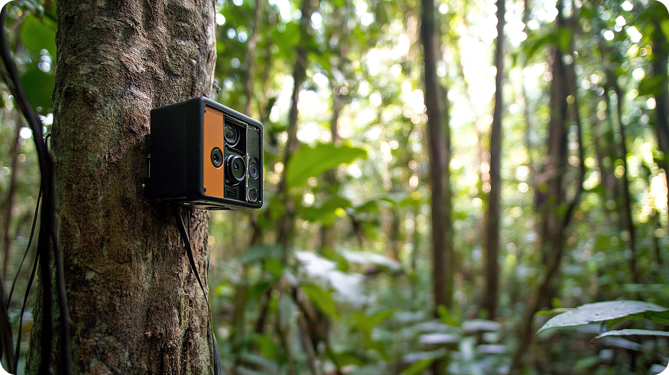
BMD supports the plug-n-play deployment of a number of camera traps. The images captured by the devices are identified by AI algorithms that find their initial development in the MAMBO (Modern Approaches to the Monitoring of BiOdiversity) project. The ARISE infrastructure that is developed at Naturalis is ready to scale up to the EU domain. The same applies to the audio devices, known as 'Audiomoths' and 'Buggs', and their AI taxon identification services.
D2.5 Tutorial high-throughput data capture devices (image/sound) - October 2026
eDNA, or environmental DNA, enables efficient biodiversity monitoring from genetic material. All species shed DNA material in their environment. Small parts of this DNA, known as DNA barcodes, are representative for different species. By extracting of the DNA barcodes and comparison against DNA barcode reference libraries enables the detection of species. eDNA biodiversity monitoring is especially effective in freshwater and marine environments, as well as from terrestrial soil samples.
D2.6 Tutorial high-throughput data capture devices (eDNA) - February 2027
Many biodiversity datasets remain hard to access and are often known only within small expert communities. To address this, BMD offers tools and guidelines to mobilise historical baseline and legacy biodiversity data, as well as national checklists. It will make them openly available through FAIR-aligned platforms like GBIF, OBIS, ENA, and ChecklistBank—standardising and centralising access for the BMD analysis tools through their APIs, and expanding their visibility and usability for broader scientific and policy communities.
D2.3 Access gate to data mobilisation tutorials - January 2026
D2.4 Tutorial Checklist mobilisation - February 2027
BMD is identifying and cataloguing environmental datasets that represent (a)biotic and climatic conditions and potential drivers of biodiversity change in the terrestrial, freshwater and marine domains. These datasets are required for the analyses by the project's Virtual Research Environments. The Data Catalogue will provide comprehensive metadata records to facilitate FAIR and reproducible results of the VREs and provide insights in ecological, climatological and land use conditions that determine the distribution of species and habitats across Europe.
D2.1 BMD Data Catalogue - first release - February 2027
D2.2 BMD Data Catalogue - final release - February 2028
The environmental, climatic, and remote sensing datasets compiled in BMD's Data Catalogue – covering terrestrial, freshwater, and marine realms – are transformed using the data cube technology developed in the B-Cubed project. These data cubes will enable efficient temporal and spatial queries without requiring users to know file names or storage locations.
D3.1 Data cube engine - July 2026
Taxonomic data collected in WP2 is shared through the Catalogue of Life's ChecklistBank, making it easy to access, download, and analyse information about species from many sources. This system will help improve how species lists are managed, harmonised and connected to environmental policies, allowing faster and simpler use of biodiversity data for research and conservation.
D3.2 Enhanced Catalogue of Life Checklist - August 2027
Using advanced spatial and temporal analysis tools, including GIS modelling and AI, BMD is identifying gaps and biases by comparing current data with information on geographical and ecological distributions, diversity, and ecosystem types. This process will highlight underrepresented regions and taxa important for policy, develop error and accuracy maps and propose solutions to fill missing data services or types.
D3.3 Gap and bias surfaces - November 2026
BMD is designing a Biodiversity Data Space as a secure, technology-agnostic platform, designed according to FAIR and Green Deal Data Space principles, for on-demand integration, storage, analysis and sharing of biodiversity data. It combines scalable cloud computing, REST APIs and a built-in map-visualisation engine to consult biodiversity, environmental and climatic data, support VRE analyses, Natura 2000 reporting and wider reuse via the EU Green Deal Data Space and EOSC.
D4.1 First version of the BMD data space released - February 2027
D4.2 Data architecture and API documentation - June 2028
D4.5 Demonstrator showing integration results with Green Deal data space and EOSC - August 2028
BMD is developing a cloud computing service providing on-demand brokering and delivery of IT and compute resources within the Data Space for intensive modelling and analysis. Using an infrastructure-as-code approach, the project will automate the provisioning of scalable cloud infrastructures for VREs.
D4.3 Load balancer implementation for compute backends - October 2027
The harmonised data and the outputs from BMD's VREs will be visualised via the web-GIS viewer that is accessible via BMD's Single Access Point through a data exploration engine and APIs. The visualisation engine enables users to search, overlay and interact with large geospatial datasets, ranging from local Natura 2000 sites to EU-wide species distributions. Built with scalable web technologies and standard formats like GeoJSON and WMS, it will ensure fast, real-time access to data and analysis that is visualised via the web-GIS viewer interface.
D4.4 Data/map visualisation engine - February 2028
Together with stakeholders, BMD is building a suite of analysis tools or Virtual Research Environments (VREs) providing a comprehensive, up-to-date view of biodiversity and its evolution. The VREs will enable resource managers to pinpoint the key drivers of decline and design targeted solutions. Covering terrestrial, freshwater and marine realms at all spatial scales, the VREs will turn advanced monitoring into actionable insight to support more effective implementation of EU nature directives and inform natural resource management and policy-making. Delivered as configurable, on-demand services, these technology-driven platforms will allow users to define their own analyses – whether trend analysis of selected species in a Natura 2000 area, identification of change drivers, prediction of climate and land-use impacts or standardised Natura 2000 status reporting.
D5.3 Virtual Research Environments - February 2028